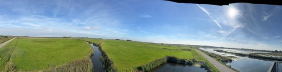
I’m writing this from the Netherlands. Today I spent the day at the Noordwaard, a former farming polder (or protected basin) on the edge of De Biesbosch National Park. I traveled here with NAFSMA (the National Association of Flood and Stormwater Management Agencies) as part of a mission to learn about flood control in other countries, and to see what lessons I might be able to bring back. I came expecting to see something new that I had never seen before. Instead, I found something I’ve been driving over on I-80 between Davis and West Sacramento in the Sacramento region for all of my career.
How the Dutch got here
The Dutch have spent roughly a thousand years building dikes (levees) higher and stronger. That approach nearly failed them in the 1990s. Two near-floods came back to back, in 1993 and again in 1995. In 1995, the Rhine, Waal, and Meuse Rivers rose to record levels and about 250,000 people and a million head of livestock were evacuated. No dike broke or was overtopped. Everyone was very lucky. But the country got the message anyway: raising dikes forever was not a winning strategy.
Their answer was Ruimte voor de Rivier, or Room for the River. It was a €2.3 billion national program of more than 30 projects, finished around 2015, all built on one idea: Instead of squeezing a rising river between ever-taller walls, you give it somewhere to go.
The Noordwaard was the largest and most complex of those projects. It covers about 4,450 hectares, roughly 11,000 acres, of reclaimed farmland. The levee on its south side was removed, so tidal water now moves in and out through restored creeks. The levee on the north side was built so that the Nieuwe Merwede spills into the polder once the river reaches about two meters above Dutch datum. In order to make room for the rivers, roughly 50 households were relocated. The homes that remain sit on new mounds (the Dutch call them terps) or inside small ring dikes. Some 700 hectares of farmland remain, clustered and ringed off, and much of the rest is grazed.
The payoff is a lowering of about 30 centimeters, roughly one foot, off the design high-water level upstream at Gorinchem. In a country where millions of people live below the water line, that foot is enormous.
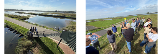
Does this sound familiar?
It should, to anyone who works in the Sacramento Valley. Standing at the project today in the Netherlands, many of us observed we could be looking at the Yolo Bypass.
The Yolo Bypass covers 59,000 acres, is about 40 miles long and up to three miles wide. At its head is the Fremont Weir, a 1.8-mile concrete lip built in 1924. It overtops on its own whenever the Sacramento River gets high enough, with no operator and no gates. In a big event the bypass carries up to 80 percent of the valley’s flood flows, around five times what the river channel can normally hold (in fact, the design flows of the two systems that the projects are part of are scarily similar). When it’s dry, most of the bypass is working farmland (much like in the Netherlands). When it’s wet, it’s an inland sea, and the fisheries biologists will tell you it’s some of the best juvenile salmon habitat in the system.
Put the two projects side by side and the design logic is nearly identical:
- a passive overflow structure that lets the river decide when it’s time;
- a working agricultural landscape that accepts periodic flooding;
- habitat as a meaningful co-benefit; and
- a stage reduction that protects the cities, Gorinchem and Dordrecht in the Netherlands, and Sacramento and West Sacramento in California.
The differences are telling too. The Dutch reached Room for the River after a millennium of dike-building and some very close calls. California reached it in 1911, after repeated levee failures convinced the State that confining the Sacramento wasn’t working. In other words, California was doing “room for the river” nearly a century before it had a name following multiple disasters. And the Noordwaard took longer, but no disasters were required.
The universal part
What struck me most wasn’t the engineering, which is excellent. It was that every flood system in the world, however well designed, is ultimately a decision about whose land gets wet so that someone else’s doesn’t.
Regular readers know I’ve spent a lot of time lately on Ideker Farms and induced flooding. When government decides where the water goes, it is also deciding who bears the burden, and courts will eventually ask whether that burden is the kind of burden that must be paid for. The Dutch took on that question up front. Rijkswaterstaat (kind of the Dutch Army Corps of Engineers) kept a representative in the Noordwaard for more than a decade. Relocations and buyouts were worked out at literal kitchen tables. The people who stayed got terps and ring dikes. The cost of making room was treated as part of the project, as it should be, and not a liability to litigate afterward.
That doesn’t translate one-for-one to our system of federal, state, and local partners, flowage rights, and inverse condemnation doctrine. But the underlying lesson travels well. The physics of a river doesn’t care what country it’s in, and neither does the question of ensuring societal fairness to the landowner in its path.
Different language. Same river. Same societal questions.