

I’ve been working through a series of posts from my September trip to the Netherlands and England with NAFSMA, touring European flood control facilities. The first post went up from the Biesbosch, and more are coming. But I’m interrupting the series because something closer to home deserves attention now.
This week, Dr. Daniel Swain, the climate scientist many Californians know as @Weather_West, posted an analysis of the latest European seasonal forecast. I’ve followed Swain for years. In fact, I met him four years ago when I invited him to Sacramento to offer a keynote speech for the California Central Valley Flood Control Association. Daniel is careful, he is not a hype merchant, and he says himself that he has sounded a genuine alarm only a handful of times in twenty years. The last time was days before the January 2025 Los Angeles fires.
This time, he wrote that he has never seen such high predictive confidence in a very wet California winter. He also said he is “officially concerned.” I want to unpack a few of his numbers, because they are remarkable, and because they need some translation.
Link to First, what is this forecast? First, what is this forecast?
The forecast comes from ECMWF, the European Centre for Medium-Range Weather Forecasts. Think of it as Europe’s joint weather-modeling shop, widely regarded as among the best in the world. Importantly, its seasonal model is not one forecast. It is 51 forecasts, called an “ensemble.” Each run starts from very slightly different conditions. The idea is that the atmosphere is chaotic, so instead of betting on one answer, you roll the dice 51 times and see where the results cluster.
Two points matter here:
- This model is not a wet outlier. Last month, Swain notes, it sat near the middle of the pack among the world’s seasonal models. It is not overly aggressive in its predictions.
- It “knows” about the ocean. Modern seasonal models couple the ocean and atmosphere in both directions. Patterns like the Pacific Decadal Oscillation (a long-cycle swing in North Pacific temperatures) are built into the physics, not left out.
Link to Why should we trust a seasonal forecast this time? Why should we trust a seasonal forecast this time?
Normally, we shouldn’t trust one much. Seasonal forecasts of California winter rain usually have only “modest skill.” Forecasters use “skill” to mean how much better a forecast does than simply assuming an average year. Usually the answer is: only a little. But this year is different because of the El Niño, which is on track to be the strongest ever recorded. Swain’s point is that skill is conditional: when the Pacific is pushed this hard, the models become much more reliable.
It also matters that this is an “east-based” El Niño, with the warmest water piled up near South America rather than in the mid-Pacific. That is the flavor historically associated with California’s big El Niño winters. He adds that other ocean and atmospheric patterns appear to be reinforcing it, and states flatly: this is not 2015–16. That winter’s hyped “Godzilla” El Niño left Southern California short. Swain is telling us not to use that experience as our template.
Link to The numbers that stopped me The numbers that stopped me
From his post, a few numbers got my attention:
Only 1 of 51 runs shows a drier-than-average winter in California. That is about 2%. It is roughly the same odds as saying you want a 2 of spades (a dry winter), and then pulling that out of a full deck. Phrased differently, it is roughly the same as saying, “you will have a wet winter unless you pull a two of spades from this deck.” Those are strong odds. Swain calls this probably as low as the odds of a dry California winter will ever look from any October.
Along the coast, 80–90% odds of a top-10% wet winter. This one deserves a second read. A “top-10% wet” winter is, by definition, one that happens, on average, about one year in ten. The model puts those odds at eight or nine in ten. That applies to most of the coast, including much of Northern California, not just the south. Swain says that in Southern California the shift is so dramatic that the expected rainfall looks like a different climate region altogether. A few runs even show record wet conditions.
The timing is concentrated. November and December lean wet, but the real signal is January through March. January and February carry the highest potential to be extremely wet.
Link to However, wet is not the same as flooded However, wet is not the same as flooded
This is the part I care most about professionally. A wet winter is a number on a rain gauge. A flood is what happens when water arrives faster than the landscape and our infrastructure can handle it. The same 40 inches of rain can be a blessing or a disaster, depending on several factors:
- Spacing. Storms a week or two apart let soils drain, rivers recede, and reservoir operators release water to restore flood space. Storms back to back don’t. The 2022–23 parade of atmospheric rivers (long, narrow bands of very moist air off the Pacific) is the recent lesson of how you would prefer the rain not to arrive.
- Snow versus rain. Snow is storage. Rain runs off now. The 1997 New Year’s flood came from warm storms dumping rain on snowpack, more than doubling our problem.
- Where it lands. The same storm means different things over a burn scar, over a full reservoir, over agricultural land that can hold the water, or against a levee that has been under strain for weeks.
Several commentators pushed back on Swain along exactly these lines: a big seasonal total doesn’t by itself mean severe flooding. He agreed, and then ran the numbers that get closer to the real question, which is how many individual months will be extremely wet.
Here is what he found:
- At least one month above 150% of average: 90–100% odds in every California region.
- At least one month above 200% of average (double a normal month): better than 50% in every region.
- Multiple such months: strikingly high odds.
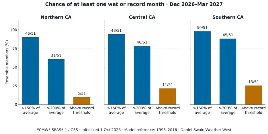
A single month at double normal is where storm spacing starts to break down. That is the statistic I would put in front of every reclamation district and flood board this fall to ensure we are ready.
Link to The warm ocean The warm ocean
One more item, easy to skim past. ECMWF shows potential ocean temperatures along the immediate California coast of 10°F or more above normal.
Warm water feeds more moisture into landfalling storms. Warmer storms also mean higher snow levels, so more of the precipitation falls as rain and runs off immediately instead of waiting in the mountains until spring. In flood terms, this is the detail that worries me most. It takes away part of the buffer the Sierra snowpack usually gives us.
Link to Where this leaves us Where this leaves us
Fortunately, the State has already started to act. Governor Newsom’s September 21 emergency proclamation is intended to speed preparations for winter storms, flooding, landslides, debris flows, and coastal flooding. Swain thinks the declaration is justified, and I agree. But the declaration only creates some flexibility, it doesn’t move the needle as much as we might need to in order to properly prepare.
El Niño still tilts the odds rather than guaranteeing outcomes, and heavy rainfall is not certain, and heavy rainfall does not automatically mean disaster. But we will rarely, if ever, get a clearer advance warning than this. Most floods are recognized in hindsight. This one, if it comes, will not be a surprise in light of what we know. Every levee maintaining agency, county, and property owner in a floodplain has roughly ten weeks before the heart of the season. That time should be spent thoughtfully.
Swain plans a dedicated Weather West blog update and YouTube livestream in the coming week. I hope to be watching, and I’d encourage you to as well. Back to the Dutch soon. As it happens, they have more than a few things to teach us about living with this much water.