

(*Chip Merlin’s Note–Rocco Calaci has been a noted meteorology expert witness in the Katrina Legal Wars. After meeting him at a recent FAPIA Convention, I invited him to write a series of guest blogs. Click here to read his previous guest blogs)
(*Note from Rocco Calaci: I started issuing a “plain talk” interpretation of National Hurricane Center bulletins at the beginning of the 2008 hurricane season. I remind everyone that this is strictly a courtesy, I have no affiliation with any government agency, this is not a commercial service and the information is not for any type of decision. It is strictly FYI).
***
There is an area of disturbed weather moving across the Atlantic and approaching the Lesser Antilles. This area may become Tropical Storm Erika in the next day or so.
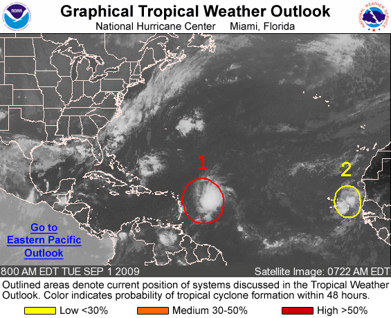
The picture above tells the whole story. As long as we have a lingering cold front along the East Coast, Erika isn’t going to be much of a threat. The problem arises if the front begins to dissipate, allowing Erika to move towards land.
All of the models are moving Erika straight for southern Florida, but it has to cross the Bahamas before it would hit Florida. At the moment, the threat area is from Miami northward to Melbourne.
If the front stays in place, Erika will move very close to the East Coast, but gradually move northward, skimming the coastline. If the front dissipates, then Miami to Melbourne are the prime areas at this time.
Based on the models, Erika isn’t expected to be more than a Category 1 hurricane. I hate to spoil the party, but models don’t always get these types of storms timed correctly.
Remember, it is still early, things can change quickly and we could have a completely different scenario within a few days.
This message is for non-operational use and is only intended to provide updates, not forecasts. Please pay attention to the bulletins issued by the National Hurricane Center (http://www.nhc.noaa.gov/).
I will begin regular distribution of messages, if and when this storm becomes Tropical Storm Erika and is a definite threat to the United States.
– Rocco